Connect with us

America

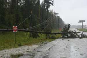
Hurricane Milton Hits Near Siesta Key as a Category 3 Storm in the US

Image
Image

Washington, DC, October 10:
The National Hurricane Center reports that Hurricane Milton, a "dangerous Category 3" storm, made landfall on Wednesday night close to Siesta Key, on the central west coast of Florida.

Just south of Sarasota lies the barrier island known as Siesta Key. At landfall, winds of 120 mph were sustained in Milton. But as it advanced inland, its power waned.

Residents of Tampa and St. Petersburg were advised by the storm center to remain indoors as "extremely dangerous hurricane-force winds" were making their way through the region.

As it loses the fuel of the warm Gulf waters, Milton will quickly weaken as it continues across Florida after impact. Nonetheless, the hurricane watch continues. On Thursday, tropical storm Milton will make its way out into the Atlantic Ocean.

According to CBS News, citing GasBuddy, as of Wednesday morning, just over 23% of gas stations in Florida were low on fuel. In the Tampa Bay and St. Petersburg area, that number rose to over 59%. Since Tuesday night, those figures had been on the rise.

Storm surge is beginning to reach along the coast of southwestern Florida, according to meteorologists, and earlier at least four twisters, one of which was a "multi-vortex tornado," were detected by the National Weather Service in Miami.

Some cities have received tornado warnings on top of the hurricane and storm surge alerts that were already in effect for many of the same locations.

On Monday, the storm intensified into a powerful Category 5 hurricane with gusts exceeding 180 mph. As the storm approached landfall, the sustained wind speeds in Milton began to decrease. Hurricane Katrina was originally predicted to be a "catastrophic" storm.

After the storm strengthened to a violent Category 3, it was anticipated that severe flooding and damage would occur.

In an interview with CBS News, scientist Jeff Masters—who had previously worked with the NOAA hurricane hunters—said, "Some of the biggest catastrophes in hurricane history were from weakening storms."

"As it drew closer to the coast, Katrina weakened, and it caused damage worth USD 190 billion," Masters stated. Upon reaching shore, the storm was downgraded from a former Cat 5 to a Cat 3. Here we have yet another storm that was a Cat 5 but will be a Cat 3 when it makes landfall—and the storm surge is already a part of it.

He pointed out, "It's going to do unprecedented damage in this part of Florida."

West coast of Florida, from Bonita Beach north to Suwannee River (including Tampa Bay), and east coast of Florida, from St. Lucie-Martin County line north to Ponte Vedra Beach, are both under a hurricane warning.

Fears of storm surges were particularly acute along Florida's western shore. Storm surge warnings extended from Flamingo northward to Yankeetown, encompassing Charlotte Harbor and Tampa Bay, in addition to hurricane warnings.

From Florida's Sebastian Inlet to Georgia's Altamaha Sound, which includes the St. Johns River, a storm surge warning was also issued for the eastern coast of the state.

A number of locations were placed under tropical storm warnings and watches, including portions of the Bahamas and Georgia.

According to the National Weather Service, "If you are in the Storm Surge Warning area, this is an extremely life-threatening situation and you should evacuate if ordered to do so by local officials."

Storm surge in the Tampa Bay area could reach 8 to 12 feet above ground level, according to the hurricane center. Previous predictions had indicated that Tampa might experience surges of up to fifteen feet; this new prognosis is a few feet lower. As of Wednesday afternoon, CBS News reported that a portion of Florida's western coast, including Sarasota and the islands of Anna Maria and Boca Grande, was expected to experience peak surges ranging from 9 to 13 feet.

Compared to prior estimates, the figures provided in the afternoon were slightly lower. Officials and meteorologists in Florida, nevertheless, emphasized that even the most conservative projections were quite high.

According to a notice issued by the hurricane center on Monday afternoon, "The deepest water will occur along the immediate coast near and to the south of the landfall location, where the surge will be accompanied by large and dangerous waves."

"Surge-related flooding depends on the relative timing of the surge and the tidal cycle, and can vary greatly over short distances," it noted, as reported by CBS News.

"Catastrophic and life-threatening flash and urban flooding, along with moderate to major river flooding" may occur in portions of the Florida peninsula through Thursday as a result of the heavy rainfall predicted for the current weather pattern.

According to Florida Governor Ron DeSantis, "we're going to have impacts far beyond wherever the eye of the storm is." This was stated during his Tuesday briefing.

He added that "The impacts will be broader ... specifically with respect to storm surge."

His statement on Wednesday was, "There will be fatalities." "When you have a storm surge of ten feet, I don't think there's any way around it," DeSantis stated. Some will remain behind, and they will be in a state of misery.

Officials in Florida have opened 149 shelters, according to DeSantis, and they can accommodate almost 200,000 people. According to CBS News, Floridians who lived in areas that the hurricane could make landfall bolstered their homes with sandbags, boarded up windows and doors, and relocated their boats in preparation for the disaster.

Over the weekend, he issued emergency measures that now include 51 counties. He warned the population to be ready to evacuate their houses if needed, have food and water supplies sufficient to last a week, and to be ready to endure power shortages. Time was running out, he said, so anyone still in the area who hadn't evacuated should go to one of the state-run or community centers set up in response to Milton.